


Six New 8000-Meter Peaks Recently Opened for Climbing
Nepal has officially listed six new 8000-meter peaks for climbing. Discover the updated names, heights, official status, and what it means for mountaineers and expeditions.

-
 Adventure Master Trek
-
29 January, 2026
-
10 mins read
-
1146 Views
-
0 Comments
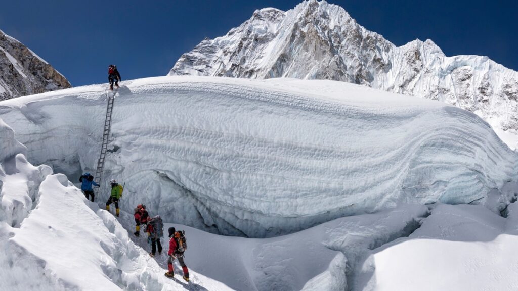
In early 2025, Nepal officially revised the peak profile of the country, and six more summits with an elevation of more than 8,000 meters were officially recognized by the country’s Department of Tourism.
This alteration elevates Nepal’s domestic total of 14 peaks of above 8,000 meters, and to the national registry, subsidiary summits in Kanchenjunga and Lhotse massifs are added. Even though these six objectives are awaiting international approval by the Union Internationale des Associations d’Alpinisme (UIAA), now the climbers may request an independent climbing permit to the objectives in Nepal as part of the current system.
This paper includes extensive profiles, climbing history, logistics, access, seasons, risks and support infrastructure of each peak, based on official surveys, historical ascents and expedition information.
Latest Peaks in Nepal: Extending the Eight Thousanders Frontier.
The official addition of six new summits above 8,000 meters to the national registry in Nepal, which has long been regarded as the ultimate destination in high-altitude mountaineering, has made the country a total of 14 eight-thousanders, officially recognized.

Climbers can now access detailed permits, defined approaches, and logistical frameworks to attempt these peaks, making Nepal’s high Himalaya even more enticing for adventurers and professionals alike.
Yalung Khang (8,505m)
Yalung Khang (formerly, Yalungskar) is a high subsidiary summit in the Kanchenjunga Himal of the Phaktanglung Rural Municipality, Taplejung District. The summit is on the western side of the Kanchenjunga massif, and was established as a separate summit in Nepal in 2025, based on peak profile according to topographic prominence and GIS qualifications (col distance >500m).
Key Data
- Elevation: 8,505 meters
- Prominence: ~135m
- Parent Range: Kanchenjunga Himal.
- Coordinates: ~27°42’18″N, 88°08’19″E
Expedition History
In May 1973, a Japanese expedition became the first to make a successful ascent via the southwest ridge and this marked a major technical achievement in ice and mixed terrain on extremely high altitude. Yalungs Khang has had very few repeats of its routes compared with other Himalayan 8000ers, although there were intermittent ascents of the mountain over the following decades.
Technical Profile and Climbing Routes.
It has two major objective lines:
- Southwest Ridge – Historical line of the first ascent, which requires permanent ice slopes and combined climbing to ED (Extremely Difficult) territory.
- Variations of South Face – Sharp snow and ice gullies, which involve fixed ropes and special avalanche control.
The strategy incorporates going through the Yalung Glacier basin. The faces of Yalung Khang are glaciated and have corniced ridgelines which, combined with objective hazards, add to technical demands and make the route harder than many commercial routes to 8000m.
Permits and Access
Climbers need a permit to climb 8000m through the Nepal Department of Tourism. The cost of permits is also determined by season and the size of the team, yet it can cost in the mid- to high-thousands of USD per climber and in the past time of year, spring rates have been higher due to demand.
The 3-6 months should be used by the climbers with a licensed agency with a liaison officer. It is generally approached by air to Biratnagar or Bhadrapur, by road across Nepal to Taplejung and a 60-70 km walk through Yamphudin, Tseram and Ramche in less than 10-14 days to the base camp area.
Logistics, Support, and Risks
Yalung Khang expeditions are usually of 60-75 days with approach, acclimatization, fixed ropes, summit window and descent. Support of loads is provided by local Sherpa and Rai porters, and when heavy equipment is to be transported up to a given high camp, where conditions allow the use of yaks. There remains the costly and weather-dependent evacuation of base camp or elevated location via helicopters which can easily cost more than several thousand USD. Hazards include:
- Objective exposure to avalanches.
- Icefall and serac collapses
- Glacial approach crevasse fields.
The limited rescue facilities require climbers to be able to repair their routes self-sufficiently, provide weather updates and make high-altitude decisions independently.
Yalung Khang West (8,077m)
Yalung Khang West is some 1.7 km south-south east of Yalung Khang proper in the same massif and district. Its altitude, being over 8,000 meters (2013) was also considered high enough to be formally included in Nepal 2025 peak profile despite the fact that it was being recognized that early.
Key Data
- Elevation: 8,077 meters
- Place: Taplejung District, Phaktanglung.
- Popularity compared to the closest ridges was developed through GIS to classify.
Climbing Status
The Yalung Khang West had not been climbed as of early 2026 ever climbed. It is technically characterized by steep ice cliffs, bare ridges and high objective risk, with only elite teams that have high alpine and high altitude experience. This peak does not have a set route or recurring beta.
Access and Logistics
The approach to access is the same as Yalung Khang; the base camps are situated in glacial feeder valleys. Longer total periods (greater than 75 days) are predicted in expedition planning in order to include reconnaissance and possible route development. Helicopter support is considered contingency since they are remote, which means that a lot of logistical resources are needed to supply early-season ascents, or ones which explore new routes.
Risks and Considerations
The major challenges facing Yalung Khang West are:
- No ascents or any common ways.
- Steep face avalanche possibilities are high.
- Notable objective exposure because of remoteness.
The mountain nowadays attracts mountaineering individuals only when it comes to the exploration teams and alpine purists.
Kanchenjunga South (8,476m)
On the southeastern side of the main Kanchenjunga massif is a subsidiary mountain called Kanchenjunga South. Although it has always been known topographically, the fact that it is above 8,000 meters and a separate col saddle has been officially registered by the Department of Tourism in Nepal, to permit permits.
Key Data
- Elevation: 8,476 meters
- Place: Taplejung District.
- Latitude: 28.654° N. Longitude: 82.242° E.
Expedition History
The initial recorded summits of the subsidiary high points of Kanchenjunga took place in the late 1970s when Kanchenjunga was being undertaken in larger groups. The climbing history of the south summit is minimal, and little is known about the number of successful ascents and the fact that it is a challenging place in ice and mixed conditions.
Climbing Routes
Standard routes go by the base camp valley systems at Kanchenjunga (via Tseram, Ramche), with high camps set on buttresses and ridges that head towards the south summit. The face entails sharp snow descents, ice couloirs, and crevasses. Difficulties of technical rating will commonly result in ED (Extremely Difficult), owing to continuous steep sections.
Permits and Access
Nepal has 8000m peak protocols, which are in line with permit protocols. The standard access procedure includes flights into Taplejung, long walks into the base camp (10-14 days), and rotations of acclimatization. Registration is required with a licensed operator, and submission of necessary documentation is to be made in time.
Kanchenjunga Central (8,473m)
Kanchenjunga Central is immediately to the north of the South peak on the massif and has been made an independent peak by the new standards of Nepal. Its saddle isolation and col measurements were of separate classification.
Key Data
- Elevation: 8,473 meters
- Place: Taplejung District.
- Relationship: Mid-summit on the Kanchenjunga southern ridge.
Climbing and Routes
The history of climbing Kanchenjunga Central is similar to the history of climbing the South summit routes, which are typically included in larger crossings of the southern shoulder. Crossings between the south peak and central have exposed ridges and ice/rock features.
Access and Logistics
The access and permit regulations are similar to Kanchenjunga South and Yalung Kang with extensive trekking and high camps being reached using the traditional Kanchenjunga valleys.
Lhotse Middle (8,410m)
Lhotse Middle (also Lhotse Central I and Lhotse East) is a side ridge peak of the Lhotse massif in Solukhumbu District. Its height and relative remoteness made it eligible for the new peak profile of Nepal.
Key Data
- Elevation: 8,410 meters
- Parent Peak: Lhotse (8,516m)
- First Ascent: 23 May 2001 by a Russian team.
Climbing Profile
First into Lhotse, Middle mountaineers ascended in 2001 using snow and rock climbing routes on the ridge between the main and Shar summits of Lhotse. Due to its positioning between two larger summits, its subsidiary status (around 60m), it was not previously recognized as a separate eight-thousander internationally; the 2025 naming of Nepal makes its status official within the country.
Access
Expeditions on Lhotse Middle follow the same line of access as Everest and Lhotse, and fly into Lukla, then an 8-10-day walk through Namche Bazaar, Gorakshep, and Everest Base Camp (EBC). The normal Lhotse trail branches off the Everest path above Camp III to the Lhotse face.
Lhotse Shar (8,400m)
Another auxiliary peak on the Lhotse massif is called Lhotse Shar, is to the east of the main Lhotse summit ridge. It was first summited on 12 May 1970 by Sepp Mayerl and Rolf Walter, and its steep faces and elevation have earned an image as a challenging goal.
Key Data
- Elevation: 8,400 meters
- First ascending: 12 May 1970 (Sepp Mayerl and Rolf Walter)
Climbing History and Risks
Climbing routes of Lhotse Shar are not the usual Lhotse main and access approaches, but open rock and ice slopes that expose climbers to a great risk of avalanches. Historical records show that the fatality ratio is very high in comparison to the attempts, and this is due to the objective terrain dangers as well as extreme weather.
Access and Logistics
It is the same as the Lhotse Middle using Lukla and the Everest Base Camp route. The preliminary infrastructure of expeditions is also similar to the Everest and Lhotse expeditions, and the higher camps and route details are programmed to the ridgelines of the Shar.
Comparison and implications
These six additional peaks, which were recently included on the official Nepalese list of 8000 m peaks, Yalung Khang, Yalung Khang West, Kanchenjunga Central, Kanchenjunga South, Lhotse Middle and Lhotse Shar, give Nepal a total of 14 officially verified peaks above 8,000 meters in stature. The historic list of 14 classic eight-thousanders (Everest, Kanchenjunga, Lhotse, Makalu, Cho Oyu, Dhaulagiri I, Manaslu, Annapurna I and five in Pakistan and one in China) is still not officially recognized internationally pending the approval of UIAA.
These implications for the Nepalese mountaineering scene are increased access to high-altitude expeditions, more technical goals, possibly greater permit fees, and a more diffuse distribution of climbing activity than standard routes.
Nonetheless, the majority of new ascents offer advanced technical factors, renowned objective dangers and insufficient established route infrastructures, and thus are located in the exclusive expeditionary programs rather than large-scale business endeavors.
Conclusion
The official status of six subsidiary peaks above 8,000 meters granted by Nepal is an important breakthrough in Himalayan mountaineering. The challenges are different on every peak: the remote exploratory opportunities of Yalung Khang West, to the technical heritage of Kanchenjunga South, and the capabilities of the high-altitude routes of Lhotse Middle and Shar.
The climbers should strike a balance between challenging goals, intense training, careful risk evaluation, and effective logistical management. Although the international recognition of UIAA is still awaited, with the permission to operate within the regulatory framework of Nepal, an expedition team can pursue these goals with the increasing infrastructure.
Ready to push beyond the classic eight-thousanders and explore Nepal’s newest high-altitude frontiers?
Contact Adventure Masters Trek today to start planning your next summit.
Comments (0)
Write a commentRead the latest Blogs & Insights
Explore our collection of articles and insights to gain in-depth travel knowledge, expert advice, and stay updated on the latest trends and tips.

No comments yet.