









Top-Rated GPS Devices for Everest Base Camp Trekking (2026 Guide)
Most trekkers heading to Everest Base Camp assume the trail is well-marked enough that navigation tools are optional. And honestly, for the most-traveled sections between Lukla and Namche Bazaar, that assumption holds. Tea houses are frequent, trail signs exist, and there are usually other trekkers moving in the same direction. But the trail changes character […]
-
 Adventure Master Trek
-
29 May, 2026
-
18 mins read
-
783 Views
-
0 Comments


Most trekkers heading to Everest Base Camp assume the trail is well-marked enough that navigation tools are optional. And honestly, for the most-traveled sections between Lukla and Namche Bazaar, that assumption holds. Tea houses are frequent, trail signs exist, and there are usually other trekkers moving in the same direction.
But the trail changes character above Namche. Fog rolls in without warning at Tengboche. Snow obscures the path between Lobuche and Gorak Shep. Side trails near Dughla appear convincingly similar to the main route in low visibility. And for trekkers adding Kala Patthar or the Three Passes variation to their itinerary, the terrain becomes genuinely complex in ways that a phone with downloaded maps does not handle reliably in cold temperatures and at altitude.
A dedicated GPS device on EBC is not about replacing common sense or a knowledgeable guide. It is about having something in the pack that works at minus 15°C, holds battery through a full trekking day, does not depend on a mobile signal, and provides accurate position data when the weather makes visibility a problem. This guide covers which GPS devices actually meet that standard, what to look for before buying, and why some popular options that work well at lower altitudes fall short in the Khumbu.
Why a Dedicated GPS Device Matters on Everest Base Camp
There is a reasonable argument that smartphones with offline maps are sufficient for most of the EBC route under normal conditions. That argument weakens considerably once the specific demands of high-altitude Himalayan trekking are applied.
Battery performance collapses in cold temperatures. Lithium-ion batteries, which power every smartphone, lose capacity rapidly below zero. A phone that holds a twelve-hour charge at room temperature might manage three hours at minus 10°C, and that degradation accelerates as temperatures drop further.
Dedicated GPS devices from Garmin and other manufacturers use battery chemistry and power management specifically optimized for cold-weather use. The difference in real-world battery life between a smartphone and a purpose-built GPS at Lobuche temperatures is not marginal. It is the difference between a device that works and one that does not.
Mobile connectivity is unreliable above certain elevations. Nepal’s mobile network has improved considerably in recent years, and coverage exists along portions of the EBC trail. But it is inconsistent, sometimes absent entirely at higher elevations, and completely irrelevant for GPS functionality in any case. A dedicated GPS device uses satellite positioning that functions regardless of mobile network availability. It works in the middle of the Khumbu glacier the same way it works in Kathmandu.
Screen visibility in bright Himalayan sunlight. Smartphone screens, even at maximum brightness, are difficult to read in the intense reflected light that comes off snow at high altitude. Dedicated GPS devices use transflective displays specifically designed to remain readable in direct sunlight without requiring significant battery drain to power high-brightness backlights.
Durability against the physical environment. A GPS device built for outdoor use handles drops, moisture, dust, and temperature cycling differently than a smartphone. Purpose-built GPS units from brands like Garmin are rated for these conditions in ways that consumer electronics generally are not.
Emergency communication capability. Several GPS devices now combine navigation with satellite messaging and SOS functionality. On the EBC route, where emergency evacuation requires helicopter rescue due to the terrain, the ability to send a precise location to a rescue coordination center without relying on mobile coverage is genuinely valuable and not a feature that can be replicated with a smartphone in areas without connectivity.
What to Look for in a GPS Device for EBC
Understanding the specifications that matter for Himalayan trekking makes the device comparisons easier to evaluate honestly.
Operating temperature range. Most consumer electronics are rated to 0°C. Dedicated outdoor GPS devices are typically rated to minus 20°C or lower. At Gorak Shep and EBC, pre-dawn temperatures regularly hit minus 15°C or below during the main trekking seasons. A device rated only to 0°C is not appropriate for this environment regardless of how capable it is in other respects.
Battery life across a full trekking day. A minimum of 16 hours of active GPS use is the practical standard for EBC. Some days involve longer than expected walks, difficult terrain that slows progress, and extended time at viewpoints or rest stops. A device that depletes at hour twelve before reaching a teahouse creates a situation where the navigation tool is unavailable exactly when fatigue and low visibility make navigation most important.
Water resistance rating. IPX7 is the minimum useful rating for Himalayan conditions, providing protection against submersion up to one meter. The EBC trail involves stream crossings, wet snow, and precipitation. A device that fails at the first stream crossing is not usable on this route.
Preloaded topographic maps. Downloading maps to a device before leaving a region with reliable internet is important preparation. Devices with preloaded topographic data for Nepal and the Himalayan region remove the risk of arriving with incomplete map coverage. The TOPO maps available for the Garmin ecosystem cover the EBC region in useful detail.
Weight and packability. Trekkers who are already managing pack weight carefully need GPS devices that do not add significant load. The best devices in this category weigh under 200 grams and fit in a hip belt pocket.
Satellite network compatibility. Devices that access multiple satellite networks (GPS, GLONASS, Galileo, and the newer multi-band systems) achieve faster position locks and better accuracy in terrain with limited sky view, such as narrow valleys and sections where high ridgelines obstruct satellite access.
Top-Rated GPS Devices for Everest Base Camp Trekking
Garmin inReach Mini 2
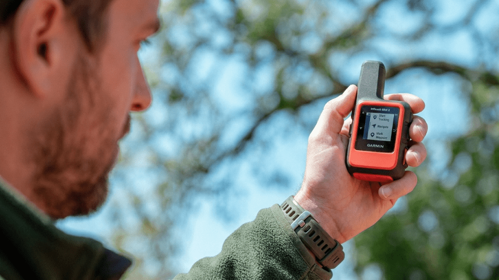
The inReach Mini 2 occupies an interesting position in the EBC GPS conversation because it is not a traditional navigation device in the handheld GPS sense. What it is, and what makes it arguably the single most valuable piece of technology on an EBC trek, is a satellite communicator that allows two-way text messaging and SOS capability anywhere on the planet via the Iridium satellite network, completely independent of mobile coverage.
The device pairs with a smartphone app for map display and navigation, or it works as a standalone communicator when the phone is not available. The SOS function connects to the GEOS International Emergency Response Coordination Center, which manages rescue coordination and contacts local emergency services with precise GPS coordinates. On a trek where helicopter evacuation is the only realistic emergency response and where mobile coverage is unreliable, that capability is not a luxury.
Battery life runs to approximately 14 days in standard tracking mode, which covers the full EBC itinerary on a single charge. The device weighs 100 grams and fits in a shirt pocket. The satellite messaging subscription required to use the service adds a monthly cost, but the range of plans includes short-term options appropriate for a single trek rather than requiring year-round subscription.
The inReach Mini 2 is best used in combination with a separate navigation GPS or a phone with offline maps rather than as a standalone navigation solution. Its satellite communication capability, however, is unmatched by anything else in this category.
Best for: Emergency communication, satellite messaging, SOS on remote sections. Pair with a navigation device for full capability.
Garmin GPSMAP 67
The GPSMAP 67 is the current flagship handheld GPS from Garmin and the device most experienced Himalayan trekkers would point to as the most capable overall choice for EBC. The combination of a large, readable display, multi-band GNSS support, preloaded topographic maps, and a rated battery life of 36 hours in GPS mode covers every navigation requirement the trek presents.
The operating temperature rating extends to minus 20°C, which covers the coldest conditions encountered at Gorak Shep and Base Camp during peak trekking season. The display remains readable in direct sunlight, which is a consistent problem with competitor devices and with smartphones at high altitude in snow.
The GPSMAP 67 also supports wireless connectivity for map and software updates, Bluetooth pairing with the Garmin inReach Mini 2 for integrated satellite communication display, and a barometric altimeter and 3-axis compass that provide accurate elevation and direction data independently of satellite positioning. These sensors are particularly useful in the Khumbu where rapid pressure changes indicate approaching weather before it is visible.
The device weighs 209 grams and uses two AA batteries, which is a meaningful advantage over proprietary rechargeable batteries in a location where recharging infrastructure is limited and inconsistent. Carrying spare AA batteries is simple, lightweight, and ensures the device can always be powered regardless of teahouse electricity availability.
Best for: Primary navigation on EBC, full topographic map access, all-conditions reliability, long battery life.
Garmin eTrex 32x
The eTrex 32x is the value option in Garmin’s handheld GPS lineup and performs well enough for the core navigation requirements of the standard EBC route. The device supports GLONASS alongside GPS for faster satellite acquisition, includes a basemap for the region, and accepts detailed topographic map downloads through the Garmin Connect platform.
Battery life is rated at 25 hours in GPS mode using two AA batteries, which covers full trekking days comfortably. The operating temperature range extends to minus 20°C. The IPX7 water resistance rating handles Himalayan precipitation conditions.
Where the eTrex 32x falls short of the GPSMAP 67 is in display size and resolution, multi-band satellite support, and wireless connectivity for map updates. For trekkers doing the standard EBC route and willing to load maps carefully before departing, these limitations are manageable. For trekkers doing the Three Passes variation or spending significant time navigating in poor visibility, the larger display and superior satellite acquisition of the GPSMAP 67 justify the higher cost.
The eTrex 32x weighs 142 grams, making it the lightest dedicated GPS option in this comparison, which matters for weight-conscious trekkers.
Best for: Budget-conscious trekkers on the standard EBC route, lightweight pack priority, straightforward navigation needs.
Garmin Oregon 700
The Oregon 700 sits between the eTrex 32x and the GPSMAP 67 in both price and capability. The touchscreen interface is the defining characteristic of this device, which makes map interaction more intuitive than the button-operated alternatives, though touchscreen sensitivity in gloves is a practical limitation that matters in cold Himalayan conditions.
The Oregon 700 includes a 3-inch color display significantly larger than the eTrex 32x, wireless map sharing between paired Oregon devices, and preloaded TOPO maps for the region. Battery life is rated at 16 hours using two AA batteries, which is shorter than both the eTrex 32x and the GPSMAP 67 and worth noting for trekkers planning very long summit days.
The touchscreen interface that makes the device easier to use in mild conditions becomes a liability in cold conditions where gloves are necessary. Operating a touchscreen with gloved fingers is possible but unreliable, and the alternative of removing gloves to interact with the device at minus 10°C is uncomfortable enough to discourage checking the map as frequently as navigation requires.
Best for: Trekkers who prioritize intuitive map interaction and are trekking in autumn when temperatures are more moderate at lower elevations.
Garmin Fenix 8 (Smartwatch GPS)
The Fenix 8 is not a handheld GPS device, but it earns a place in this comparison because its wrist-based form factor addresses one of the practical frustrations of handheld GPS on EBC: retrieving a device from a hip belt pocket or pack while wearing gloves, in wind, while managing trekking poles.
The Fenix 8 uses multi-band GNSS with support for GPS, GLONASS, Galileo, and BeiDou, achieving positioning accuracy that competes with dedicated handheld devices. The sapphire crystal display is genuinely readable in direct sunlight. The device includes preloaded topographic maps for global coverage, turn-by-turn navigation, and a barometric altimeter with storm alert functionality.
Battery life in GPS mode reaches approximately 43 hours with multi-band GNSS active, and the device supports solar charging on the solar variant, which provides meaningful supplemental charging during long days in high Himalayan sunshine. The operating temperature rating extends to minus 20°C.
The limitation of the Fenix 8 relative to a dedicated handheld is display size. Interpreting detailed topographic information on a 1.4-inch circular display is workable for checking current position and bearing, but less useful for studying the route ahead in detail. Trekkers who want wrist-based convenience for real-time position checking and are willing to complement it with phone-based offline maps for detailed route planning get the best of both approaches.
Best for: Trekkers who want wrist-based navigation access, those already using a Garmin smartwatch for health tracking, anyone who finds handheld GPS retrieval impractical while moving.
Garmin inReach Messenger
The inReach Messenger is the updated and expanded version of Garmin’s satellite communication line, sitting above the inReach Mini 2 in features while remaining focused on communication rather than navigation. The device offers two-way satellite messaging, location sharing, and SOS capability through the Iridium network, with the addition of a color display and faster message sending compared to the Mini 2.
For trekkers whose primary concern is communication and emergency access rather than detailed navigation, the inReach Messenger paired with a phone running offline maps represents a capable and relatively lightweight solution. The satellite subscription cost applies here as with the Mini 2.
Best for: Communication-focused trekkers who are comfortable relying on phone-based offline maps for navigation.
Suunto Traverse Alpha
The Suunto Traverse Alpha is a GPS smartwatch from the Finnish outdoor brand that competes with the lower end of the Garmin Fenix range. The device includes GPS and GLONASS satellite support, a moon phase calendar useful for planning visibility on high passes, and dedicated hunting and fishing features that are irrelevant for EBC trekking but reflect the outdoor focus of the design.
For EBC specifically, the Traverse Alpha handles basic navigation and track recording competently. The battery life of approximately 100 hours in time mode and 15 hours in full GPS mode is adequate for single-day use but requires charging at teahouses for multi-day tracking without battery conservation settings. The operating temperature handles Himalayan conditions within normal trekking season ranges.
Where Suunto falls behind Garmin in this comparison is in the map ecosystem. Garmin’s preloaded topographic coverage and the depth of the Connect platform for downloading and managing maps is more developed than Suunto’s equivalent. For trekkers who are already Suunto users and familiar with the platform, the Traverse Alpha is a competent EBC companion. For those starting fresh, Garmin’s ecosystem advantage is significant enough to influence the choice.
Best for: Existing Suunto users, trekkers wanting a capable GPS watch at a lower price point than the Fenix 8.
Himalayan Rescue Association Tracking Devices
Worth mentioning in any EBC GPS discussion is the tracking device program operated through various Nepal-based trekking agencies and the Himalayan Rescue Association. Rental GPS trackers with satellite connectivity are available in Kathmandu that provide position data to a monitoring center and allow emergency contact through partner agencies.
For trekkers who do not want to invest in device ownership and whose primary concern is emergency communication rather than active navigation, this rental option covers the safety communication requirement at lower upfront cost. The navigation capability of rental trackers is minimal compared to dedicated Garmin devices, so this option works best for guided trekkers who do not need independent navigation tools.
GPS Apps vs Dedicated GPS Devices: The Honest Comparison
Trekkers frequently ask whether apps like Gaia GPS, Maps.me, or Wikiloc with downloaded offline maps are sufficient alternatives to a dedicated GPS device for EBC. The honest answer depends on how the trek is structured and what risks the trekker considers acceptable.
Where apps perform well: On the lower sections of the EBC route in good weather, phone-based offline navigation apps with downloaded topographic data work reliably. The map interfaces on Gaia GPS and similar apps are in many ways more user-friendly than dedicated GPS displays, and the larger smartphone screen makes route planning easier.
Where apps create problems: Battery life at cold temperatures is the primary issue, as covered earlier in this guide. A smartphone being actively used for GPS navigation at altitude in cold conditions depletes faster than most trekkers expect, and the consequences of a dead phone on a remote section of trail are significant. The secondary issue is that smartphones are primary communication devices carrying irreplaceable personal data, which makes exposing them to the physical risks of a mountain environment a different calculation than exposing a purpose-built GPS that costs less and carries no personal data.
The practical recommendation most experienced EBC trekkers settle on is using a phone with offline maps as the primary navigation interface for planning and checking the route under normal conditions, combined with a dedicated device, whether a Garmin handheld or wrist GPS, for reliable real-time positioning and emergency communication.
GPS Device Rentals in Nepal
Kathmandu has rental options for GPS devices and satellite communicators, primarily through established trekking agencies in Thamel and specialized gear rental shops. Garmin inReach devices, basic handheld GPS units, and SPOT satellite communicators are available for daily rental rates that make more financial sense than purchasing for a single trek.
Quality and condition vary between rental sources. The same advice that applies to rental sleeping bags and trekking poles applies here: check the device carefully before accepting it, verify that the satellite subscription or service is active for the dates of the trek, and test the device in Kathmandu before heading to Lukla.
Satellite communicator subscriptions present a particular complexity with rental devices. Confirm with the rental provider exactly what communication service is active, what the emergency contact protocol is, and who monitors the device if an SOS is sent.
Recommended GPS Setup for Everest Base Camp
For safety-focused trekkers on a budget: Garmin eTrex 32x for navigation plus Garmin inReach Mini 2 with a short-term satellite subscription for emergency communication. This combination covers both navigation and emergency contact at a lower combined cost than the GPSMAP 67 alone.
For comprehensive capability: Garmin GPSMAP 67 as the primary navigation device, Garmin inReach Mini 2 for satellite communication, paired together via Bluetooth so position data from the GPSMAP 67 displays on the inReach app and satellite messaging is accessible without a separate device.
For trekkers preferring wrist-based navigation: Garmin Fenix 8 Solar on the wrist, Garmin inReach Mini 2 clipped to the pack shoulder strap for satellite communication access. Use the Fenix for real-time position and the Mini 2 for messaging and SOS.
For guided trekkers with minimal navigation needs: Garmin inReach Mini 2 or inReach Messenger alone, with the primary navigation handled by the guide and the satellite communicator providing emergency access and family check-in capability.
Common Mistakes with GPS Devices on EBC
Not loading maps before leaving the reliable internet. Teahouse wifi above Namche is slow, intermittent, and completely inadequate for downloading large topographic map files. Load maps in Kathmandu or before arriving in Nepal.
Relying on a single device without backup. A single device failure, whether through battery depletion, a drop onto rocks, or moisture damage, leaves a trekker without navigation tools. The recommended approach of combining a dedicated GPS with phone-based offline maps provides meaningful redundancy.
Skipping the satellite communicator subscription. Owning a Garmin inReach without an active satellite subscription is owning an expensive GPS watch clip-on. The subscription activates the satellite messaging and SOS functions. Confirm it is active before the trek begins.
Assuming any GPS device works in all temperatures. Consumer-grade GPS devices and watches rated only to 0°C will fail or perform unreliably at EBC temperatures. Check the operating temperature specification of any device before trusting it at altitude.
Carrying a GPS without learning to use it. A GPS device used for the first time on the trail in poor visibility is not a useful navigation tool. Spending a day or two in Kathmandu or on the lower trail sections understanding the device interface, map display, and waypoint marking functions is time that pays back immediately when conditions become challenging.
Conclusion
The GPS device question for EBC comes down to two separate needs that are worth distinguishing clearly. Navigation and emergency communication are related but different problems, and the best device setup addresses both rather than treating them as the same requirement.
For navigation, the Garmin GPSMAP 67 is the most capable handheld device for the conditions the EBC route presents. The eTrex 32x handles the same route at a lower price and weight. The Fenix 8 provides wrist-based navigation for trekkers who find handheld retrieval impractical. Any of these options works reliably in the temperatures and terrain of the Khumbu.
For emergency communication and safety, the Garmin inReach Mini 2 is the single most important technology investment a trekker can make for EBC. The SOS function connected to a 24-hour emergency coordination center, the satellite messaging that works independently of Nepal’s mobile network, and the location sharing that allows family and agencies to monitor progress are capabilities that a dedicated navigation GPS cannot provide.
The trekkers who arrive at Base Camp and return safely to Lukla are not necessarily the ones who carried the most sophisticated gear. They are the ones who carried gear appropriate to the environment, understood how to use it before the trail demanded it, and made sure that if something went wrong in a remote section of the Khumbu, someone with the ability to help knew exactly where they were.
Comments (0)
Write a comment- Why a Dedicated GPS Device Matters on Everest Base Camp
- What to Look for in a GPS Device for EBC
- Top-Rated GPS Devices for Everest Base Camp Trekking
- Garmin inReach Mini 2
- Garmin GPSMAP 67
- Garmin eTrex 32x
- Garmin Oregon 700
- Garmin Fenix 8 (Smartwatch GPS)
- Garmin inReach Messenger
- Suunto Traverse Alpha
- Himalayan Rescue Association Tracking Devices
- GPS Apps vs Dedicated GPS Devices: The Honest Comparison
- GPS Device Rentals in Nepal
- Recommended GPS Setup for Everest Base Camp
- Common Mistakes with GPS Devices on EBC
- Conclusion
Read the latest Blogs & Insights
Explore our collection of articles and insights to gain in-depth travel knowledge, expert advice, and stay updated on the latest trends and tips.




No comments yet.